Introduction to Mount Rinjani
Nestled on the picturesque island of Lombok, Indonesia, Mt. Rinjani stands as the second-highest volcano in the archipelago and a prominent symbol of natural beauty and cultural heritage. With its majestic presence soaring to an elevation of 3,726 meters (12,224 feet), Rinjani attracts trekkers, adventurers, photographers, and nature lovers from around the world. Its imposing stature is not merely a geographical feature but a testament to the dynamic geological history and cultural significance of the region. Whether you’re seeking an exhilarating adventure, a tranquil retreat amidst nature, or an opportunity to immerse yourself in indigenous traditions, Rinjani offers a diverse array of experiences unmatched by other volcanic landscapes in Southeast Asia.
Overview of Rinjani’s Significance
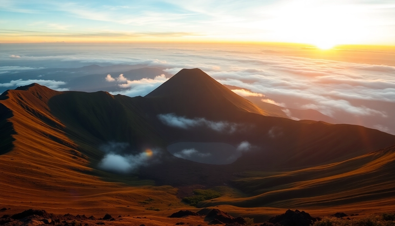
Mount Rinjani is much more than a mountain; it is the heartbeat of Lombok’s ecological, cultural, and spiritual landscape. As an active stratovolcano, Rinjani has shaped the island’s terrain for thousands of years, giving rise to lush forests, fertile valleys, and crater lakes that are teeming with biodiversity. Its caldera, known as Segara Anak, features a stunning turquoise lake, which is often regarded as one of the most beautiful volcanic lakes in the world. This natural wonder is not only a visual marvel but also a vital water source for local communities.
The mountain is also a sacred site for the Sasak and Balinese peoples, who regard it as a spiritual symbol and conduct traditional rituals to honor its power. The annual pilgrimage ceremonies and offerings highlight the mountain’s legendary status within regional folklore. Moreover, Rinjani’s status as a protected national park underscores its importance for conservation efforts, preservation of endemic flora and fauna, and sustainable tourism development.
Historical and Cultural Importance
Historically, Rinjani has played a central role in the cultural identity of the Lombok people. Archaeological findings suggest that the mountain has been a pilgrimage site for centuries, with local legends associating it with gods, spirits, and ancestral figures. Traditional ceremonies are often held at the summit and around the crater to seek blessings for harvests, safety, and prosperity.
The mountain’s volcanic activity has also influenced regional mythology. Its eruptions have been interpreted as both destructive forces and purifying events, emphasizing the balance between nature’s power and spiritual sanctity. The story of Mount Rinjani is interwoven with Lombok’s history of resilience, adaptation, and reverence for the environment.
Understanding this cultural backdrop enriches the trekking experience, allowing adventurers to appreciate the profound connection between nature and indigenous traditions. Visitors are encouraged to engage respectfully with local customs, supporting community-led tourism initiatives and preserving the mountain’s sacredness.
Key Facts and Figures
- Elevation: 3,726 meters (12,224 feet)
- Location: North Lombok Regency, West Nusa Tenggara, Indonesia
- Type of volcano: Stratovolcano
- Last Eruption: The most recent significant activity occurred in 2016, with minor eruptions and ash emissions.
- National Park Area: Approximately 41,330 hectares within the Gunung Rinjani National Park
- Biodiversity: Rich with endemic species of flora and fauna, including Rinjani scops owl, black giant squirrel, and diverse orchids
- Climate: Cooler temperatures at high altitudes with a distinctive wet and dry season, best for trekking from May to September
These facts encapsulate Rinjani’s physical dimensions and ecological importance, serving as essential information for those planning their journey or seeking to understand the mountain’s dynamics.
Preparing for Your Rinjani Trek
Best Time to Visit and Seasonal Insights
The optimal period for trekking Mount Rinjani aligns with the dry season, typically between May and September. During these months, weather conditions are more predictable, with clear skies, lower humidity, and minimal rainfall, which considerably enhances safety and comfort. Planning your trek outside this window increases risks such as slippery trails, mudslides, and sudden weather changes.
The peak season also coincides with local festivals and cultural events, providing a richer experience of Lombok’s traditions. However, it’s advisable to book guides and permits well in advance due to the surge in tourist activity during this period.
Essential Equipment and Supplies
Preparation is the key to a successful and safe Mount Rinjani trek. Essential gear includes:
- Clothing: Warm layers, windproof jacket, waterproof gear, moisture-wicking shirts, thermal underwear, hat, and gloves.
- Footwear: Sturdy, waterproof hiking boots with good ankle support.
- Sleep and Shelter: Lightweight sleeping bag, sleeping pad, and a compact tent if camping independently.
- Navigation and Safety: GPS device, map, compass, headlamp, first aid kit, and personal medication.
- Food and Hydration: High-energy snacks, water bottles, water purification tablets or filters.
Adequate preparation minimizes health risks and enhances the overall trekking experience. Local guides often provide a detailed packing list according to current trail conditions.
Choosing Guides and Permits
Engaging certified guides enhances safety, cultural understanding, and environmental responsibility. Valid permits are mandatory for all trekkers and are typically arranged through local tour operators or national park authorities. Guides not only assist with navigation and safety but also serve as cultural ambassadors, sharing insights about local traditions, flora, and fauna.
The cost of guides and porters varies but usually ranges from Rp. 350,000 per day for guides and Rp. 300,000 for porters, depending on the trek duration and services included. Prior booking and clear agreements avoid misunderstandings and ensure a smooth journey.
Trail Routes and Trekking Experience
Main Trekking Routes (Sembalun and Senaru)
Mount Rinjani offers two primary routes for trekkers: Sembalun and Senaru. Each has unique characteristics tailored to different experience levels and scenic preferences.
Sembalun Route
Starting from Sembalun Lawang, this route is revered for its relatively gentle ascent and stunning views of the surrounding valleys and rice terraces. It spans approximately 27 km and usually takes 2–3 days to complete. The route passes through savannah-like grasslands, forests, and finally reaches the crater rim, offering dramatic vistas of Segara Anak lake and the active volcano.
Senaru Route
Originating from the village of Senaru, this trail is steeper and more challenging, favored by experienced trekkers. Covering roughly 25 km, it involves more technical ascents through dense rainforests, waterfalls, and traditional Sasak villages. The route offers a closer encounter with the island’s lush biodiversity and cultural sites.
Difficulty Level and Physical Preparation
Trekking Mount Rinjani requires excellent physical condition due to altitude gains, rugged terrain, and variable weather. Both routes rate as challenging, especially ascending through steep slopes and free-flowing trails. Adequate cardiovascular training, endurance exercises, hiking practice, and altitude acclimatization are vital before attempting the summit.
Common challenges include fatigue, dehydration, and altitude sickness. Solutions involve gradual acclimatization, staying well-hydrated, consuming high-calorie foods, and listening to your body. Engaging professional guides provides tailored advice and support tailored to your fitness level.
Step-by-Step Trekking Guide
- Preparation Phase: Physical fitness, gather equipment, secure permits and guides.
- Day 1: Arrive at trailhead (Sembalun or Senaru), conduct briefing, start trek, camp overnight at designated sites.
- Day 2: Ascent to crater rim, enjoy panoramic views, set up camp near summit or downstream refuges.
- Day 3: Summit attempt early morning, enjoy sunrise views, descend to base camp, and end trek or stay longer for sightseeing.
Each step demands adherence to safety standards, environmental ethics, and respect for local communities. Proper planning ensures a rewarding experience with lasting memories.
Safety, Eruptions, and Volcanic Activity
Monitoring Rinjani’s Volcanic Activity
Rinjani’s active status necessitates continuous monitoring by volcanologists, meteorologists, and authorities. Data from seismic activity, ash emissions, and ground deformation inform eruption forecasts. The Geological Agency of Indonesia and the Rinjani National Park provide timely updates through official channels to inform visitors about potential hazards.
Visitors should stay informed via local guides, park alerts, and government advisories, especially during periods of heightened activity. Mobile apps and dedicated websites like the Smithsonian Institution’s Global Volcanism Program also offer real-time data.
Safety Precautions During Eruptions
In the event of volcanic activity, immediate evacuation protocols are activated. Trekkers should heed warnings, avoid restricted zones, and follow instructions from guides and park authorities. Common signs of impending eruptions include increased seismic activity, ash plumes, and small explosions.
During eruptions, it’s crucial to:
- Evacuate to designated safe zones immediately
- Wear masks or cloth to filter ash
- Cover exposed skin to avoid irritation
- Stay updated via radio/phone communications
Emergency Preparedness and Tips
Preparedness involves carrying a comprehensive first aid kit, understanding evacuation routes, and maintaining communication with guides. Travel insurance that covers volcanic activity and emergencies is highly recommended. Additionally, learning basic survival skills, such as creating makeshift masks and navigating in low-visibility conditions, enhances safety.
Discovering the Rinjani National Park
Flora and Fauna of Rinjani
The park encompasses a vibrant ecosystem thriving from lowland forests to alpine zones. It hosts numerous endemic species, including the rare Rinjani scops owl, the black giant squirrel, and a variety of orchids and medicinal plants. The diverse habitats provide sanctuary for migratory birds, insects, and other wildlife.
Trekkers and nature enthusiasts are encouraged to respect conservation regulations, avoid littering, and participate in eco-tourism activities that promote habitat protection and community involvement.
Tourist Attractions and Natural Hotspots
- Segara Anak Lake: A pristine crater lake with stunning turquoise hues, accessible via trekking routes and boat rides.
- Guruh Lake: Another volcanic crater lake offering unique landscape views.
- Sendang Gile and Tiu Kelep Waterfalls: Located near Senaru, these waterfalls provide scenic spots for relaxation after trekking.
- Rinjani Waterfalls: Includes several waterfalls within the park, suitable for eco-tours and photography outings.
Local Culture and Community Engagement
The communities surrounding Rinjani, mainly Sasak and Lombok indigenous groups, maintain vibrant cultural practices, craft traditions, and local hospitality. Visitors are encouraged to engage respectfully, participate in homestays, and support community-based tourism initiatives.
Educational programs and cultural exchanges foster mutual understanding and contribute to sustainable economic development in the region.